利用Python计算和可视化温度植被干旱指数(TVDI)
利用Python计算和可视化温度植被干旱指数(TVDI)
ytkz在地理空间分析领域,温度植被干旱指数(TVDI)是一种广泛采用的遥感指标,用于评估区域干旱状态。它结合了地表温度(Land Surface Temperature, LST)和归一化植被指数(Normalized Difference Vegetation Index, NDVI)的信息,可以有效揭示土壤水分状况。本文将深入探讨如何使用Python中的GDAL、NumPy和Matplotlib库来处理地理空间数据,计算TVDI,并将其可视化。
准备工作
确保安装了以下库:
- GDAL:用于地理空间数据的操作和读取。
- NumPy:用于高效数组处理和数学运算。
- Matplotlib:用于数据可视化。
实现细节
数据准备与读取
首先,我们需要从TIFF文件中读取NDVI和LST数据。这可以通过GDAL的gdal.Open()函数完成,随后使用GetRasterBand().ReadAsArray()方法将波段数据转换为NumPy数组。
def get_data(file_ndvi, file_lst):
    ndvi_tif = gdal.Open(file_ndvi, gdal.GA_ReadOnly)
    lst_tif = gdal.Open(file_lst, gdal.GA_ReadOnly)
    ndvi = ndvi_tif.GetRasterBand(1).ReadAsArray()
    lst = lst_tif.GetRasterBand(1).ReadAsArray()
    return ndvi, lst
计算TVDI
TVDI的计算涉及以下几个关键步骤:
- 确定LST的湿边(最小值)和干边(最大值)。
- 使用线性回归拟合湿边和干边。
- 应用拟合的模型计算TVDI。
这里我们创建了一个向量化的NDVI序列,并通过遍历此序列来确定在每个NDVI值附近LST的范围。然后,我们对这些值进行线性拟合,最终计算出TVDI。
def compute_tvdi(ndvi, lst, MinPfit, MaxPfit):
Ts_max = b1 + (a1 * ndvi)
Ts_min = b2 + (a2 * ndvi)
TVDI = (lst - Ts_min) / (Ts_max - Ts_min)
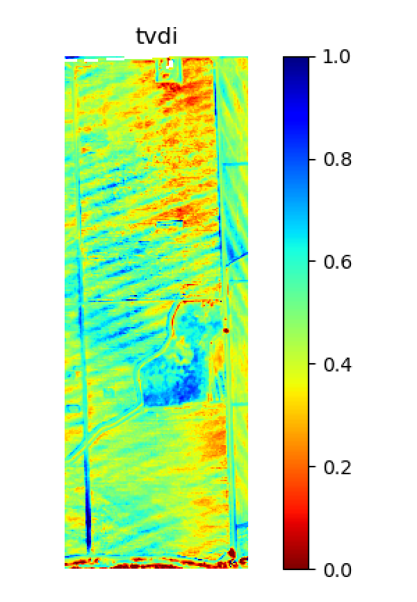
return TVDI数据可视化与保存
为了更好地理解数据,我们使用Matplotlib绘制了NDVI与LST的散点图,以及拟合的湿边和干边线。此外,还生成了TVDI的热力图。
def plot_scatter(ndvi, lst, MiniList, MaxList, MinPfit, MaxPfit, scatter_file=None):
    plt.plot(ndvi.ravel(), lst.ravel(), "+", color='dimgray', markersize=4)
    plt.plot([0, 1], linhamax, color='r', markersize=8, label="Tsmax")
    plt.plot([0, 1], linhamin, color='b', markersize=8, label="Tsmin")
    plt.legend()
    plt.show()

def show_tvdi(tvdi, fig_file=None):
    plt.imshow(tvdi, cmap='jet_r', vmax=1, vmin=0)
    plt.colorbar()
    plt.show()
最后,我们将计算得到的TVDI数据保存回一个新的TIFF文件,以便进一步的GIS分析或存档。
def save_tvdi(TVDI, gt, proj, dtype, file_out):
    driver = gdal.GetDriverByName('GTiff')
    dset_output = driver.Create(file_out, TVDI.shape[1], TVDI.shape[0], , gdal.GDT_Float32)
    dset_output.SetGeoTransform(gt)
    dset_output.SetProjection(proj)
    dset_output.GetRasterBand(1).WriteArray(TVDI)
    dset_output.FlushCache()
    dset_output = None
完整代码
#!/usr/bin/env python
# -*- coding: utf-8 -*-
# @Time : 2024/7/15
# @File : TVDI.py
'''
Main TVDI program
Adapted for Python by ytkz
'''
from osgeo import gdal
import numpy as np
import matplotlib.pyplot as plt


# 获取lst、ndvi数据
def get_data(file_ndvi, file_lst):
    ndvi_tif = gdal.Open(file_ndvi, gdal.GA_ReadOnly)
    lst_tif = gdal.Open(file_lst, gdal.GA_ReadOnly)
    ndvi_band = ndvi_tif.GetRasterBand(1)
    ndvi = ndvi_band.ReadAsArray()
    lst_band = lst_tif.GetRasterBand(1)
    lst = lst_band.ReadAsArray()
    return ndvi, lst


# 获取投影等信息,用于保存TVDI结果
def get_info(file_ndvi):
    ndvi_tif = gdal.Open(file_ndvi, gdal.GA_ReadOnly)
    ndvi_band = ndvi_tif.GetRasterBand(1)
    gt = ndvi_tif.GetGeoTransform()
    proj = ndvi_tif.GetProjectionRef()
    dtype = ndvi_band.DataType
    return gt, proj, dtype


# 计算lst的最小值(湿边)和最大值(干边)
def get_min_max(ndvi, lst):
    MiniList = []
    MaxList = []
    # 创建ndvi向量(0到1,间距为0.01)
    ndvi_vector = np.round(np.arange(0.01, 1.01, 0.01), 2)
    # 首先找到相同ndvi的lst值
    for val in ndvi_vector:
        lst_lst_val = []
        row, col = np.where((ndvi >= val - 0.001) & (ndvi <= val + 0.001))
        # 根据这些ndvi的位置,我们取温度值对应这些位置(行和列)
        for i in range(len(row)):
            if np.isfinite(lst[row[i], col[i]]):
                lst_lst_val += [lst[row[i], col[i]]]
            # 如果所需的ndvi有lst值,则计算最大值和最小值
        if lst_lst_val != []:
            lst_min_val = np.min(lst_lst_val)
            lst_max_val = np.max(lst_lst_val)
        else:
            lst_min_val = np.nan
            lst_max_val = np.nan
        # 找到的值被添加到MiniList和MaxList列表中
        MiniList += [lst_min_val]
        MaxList += [lst_max_val]
    return MiniList, MaxList


def fit(MiniList, MaxList):
    ndvi_vector = np.round(np.arange(0.01, 1.01, 0.01), 2)
    MiniList_fin = []
    ndvi_fin = []
    for i, val in enumerate(MiniList):
        if np.isfinite(val):
            MiniList_fin += [val]
            ndvi_fin += [ndvi_vector[i]]
    MinPfit = np.polyfit(ndvi_fin[14:89], MiniList_fin[14:89], 1)
    MaxList_fin = []
    ndvi_fin = []
    for i, val in enumerate(MaxList):
        if np.isfinite(val):
            MaxList_fin += [val]
            ndvi_fin += [ndvi_vector[i]]
    MaxPfit = np.polyfit(ndvi_fin[14:89], MaxList_fin[14:89], 1)
    return MinPfit, MaxPfit


def plot_scatter(ndvi, lst, MiniList, MaxList, MinPfit, MaxPfit, scatter_file=None):
    ndvi_vector = np.round(np.arange(0.01, 1.01, 0.01), 2)
    a1, b1 = MaxPfit
    a2, b2 = MinPfit
    linhamax = [b1 + (a1 * 0), b1 + (a1 * 1)]
    linhamin = [b2 + (a2 * 0), b2 + (a2 * 1)]

    plt.plot(ndvi.ravel(), lst.ravel(), "+", color='dimgray', markersize=4)
    plt.plot(ndvi_vector[14:89], MiniList[14:89], '+', color='b')
    plt.plot(ndvi_vector[14:89], MaxList[14:89], '+', color='r')
    if a1 > 0:
        plt.plot([0, 1], linhamax, color='r', markersize=8,
                 label=f"Tsmax = {'%.1f' % b1} + {'%.1f' % abs(a1)} * ndvi")
    else:

        plt.plot([0, 1], linhamax, color='r', markersize=8,
                 label=f"Tsmax = {'%.1f' % b1} - {'%.1f' % abs(a1)} * ndvi")
    if a2 > 0:
        plt.plot([0, 1], linhamin, color='b', markersize=8,
                 label=f"Tsmin = {'%.1f' % b2} + {'%.1f' % abs(a2)} * ndvi")
    else:
        plt.plot([0, 1], linhamin, color='b', markersize=8,
                 label=f"Tsmin = {'%.1f' % b2} - {'%.1f' % abs(a2)} * ndvi")
    plt.legend(loc='upper right', fontsize=12)
    plt.ylim(top=340, bottom=270)
    plt.xlabel("ndvi")
    plt.ylabel("lst (K)")
    plt.title("ndvi vs lst Scatterplot")
    if scatter_file is not None:
        plt.savefig(scatter_file)
    plt.show()


def show_tvdi(tvdi, fig_file=None):
    plt.imshow(tvdi, cmap='jet_r', vmax=1, vmin=0)
    plt.axis('off')
    plt.colorbar()
    plt.title("tvdi")
    if fig_file is not None:
        plt.savefig(fig_file)
    plt.show()


def compute_tvdi(ndvi, lst, MinPfit, MaxPfit):
    a1, b1 = MaxPfit
    a2, b2 = MinPfit

    Ts_max = b1 + (a1 * ndvi)
    Ts_min = b2 + (a2 * ndvi)

    TVDI = (lst - Ts_min) / (Ts_max - Ts_min)

    return TVDI


def save_tvdi(TVDI, gt, proj, dtype, file_out):
    fname_out = file_out
    driver = gdal.GetDriverByName('GTiff')
    data_type = dtype
    dset_output = driver.Create(fname_out, TVDI.shape[1], TVDI.shape[0], 1, gdal.GDT_Float32)
    dset_output.SetGeoTransform(gt)
    dset_output.SetProjection(proj)
    dset_output.GetRasterBand(1).WriteArray(TVDI)
    dset_output.FlushCache()
    dset_output = None


def main(ndvi_file, lst_file, tvdi_file, scatter_file=None, fig_file=None):
    '''
    Parameters
    ----------
    ndvi_file : the file of ndvi

    lst_file : the file of lst

    tvdi_file : the file use to save tvdi

    scatter_file : the file use to save scatter

    fig_file : the file use to save the figure of tvdi
    '''
    # 获取ndvi和lst数据
    ndvi, lst = get_data(ndvi_file, lst_file)
    ndvi[ndvi < 0] = np.nan
    lst[lst < 250] = np.nan
    # 获取lst的最小值(湿边)和最大值(干边)
    MiniList, MaxList = get_min_max(ndvi, lst)
    # 计算tvdi,并保存
    MinPfit, MaxPfit = fit(MiniList, MaxList)
    tvdi = compute_tvdi(ndvi, lst, MinPfit, MaxPfit)
    gt, proj, dtype = get_info(ndvi_file)
    save_tvdi(tvdi, gt, proj, dtype, tvdi_file)
    # 显示散点图
    plot_scatter(ndvi, lst, MiniList, MaxList, MinPfit, MaxPfit, scatter_file)
    # 展示tvdi结果
    show_tvdi(tvdi, fig_file)


if __name__ == '__main__':
    ndvi_file = r'NDVI_example.tif'
    lst_file = r'LST_example.tif'
    tvdi_file = r'TVDI.tif'

    main(ndvi_file, lst_file, tvdi_file)
结果展示
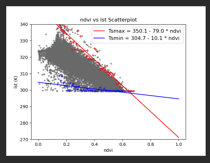
结论
通过上述Python脚本,我们能够高效地计算并可视化TVDI,从而为干旱监测和水资源管理提供科学依据。