lee滤波对于sar影像去噪非常有用

lee滤波对于sar影像去噪非常有用
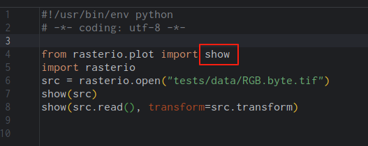
ytkzlee滤波对于sar影像去噪非常有用。且lee滤波也很容易理解,且看以下python代码编写的lee滤波函数。
import numpy as np
from scipy.ndimage import uniform_filter

def lee_filter(img, size, global_variance):
    """
    Apply Lee filter for speckle noise reduction using a global variance.
    """
    img_mean = uniform_filter(img, (size, size))
    img_sqr_mean = uniform_filter(img ** 2, (size, size))
    img_variance = img_sqr_mean - img_mean ** 2

    # Avoid division by zero or invalid operations
    denominator = img_variance + global_variance
    denominator[denominator == 0] = 1e-9  # Prevent division by zero

    img_weights = img_variance / denominator
    img_output = img_mean + img_weights * (img - img_mean)
    return img_output
但是在实际处理时,我们一般还要做一些处理,比如规定好输入、输出。一般来说,遥感影像是巨大的,所以我们也要考虑到硬件的性能。
以下是我所使用的改进的代码,仅供参考。
import numpy as np
from scipy.ndimage import uniform_filter
from osgeo import gdal
import sys
def translate(band, number=2):
"""
Convert the value of a band to the range 0-255 for visualization
2% linear conversion
"""
if np.all(np.isnan(band)) or not np.any(band):
return np.zeros_like(band, dtype=np.uint8)
max_val = np.nanmax(band)
min_val = np.nanmin(band)
if max_val == 0:
return np.zeros_like(band, dtype=np.uint8)
band = band.astype(np.float64)
band[band == -9999] = np.nan
band[band == 0] = np.nan
band_data = band / max_val * 255
band_data[np.isnan(band_data)] = 0
d2 = np.percentile(band_data, number)
u98 = np.percentile(band_data, 100 - number)
if u98 - d2 == 0:
return np.zeros_like(band, dtype=np.uint8)
maxout = 255
minout = 0
data_8bit_new = minout + ((band_data - d2) / (u98 - d2)) * (maxout - minout)
data_8bit_new[data_8bit_new < minout] = minout
data_8bit_new[data_8bit_new > maxout] = maxout
return data_8bit_new
def read_img(file):
"""
Read a Sentinel-1 GeoTIFF image and return its data, geotransform, projection, and GCPs.
"""
dataset = gdal.Open(file)
if dataset is None:
raise FileNotFoundError(f"Could not open {file}")
img_width = dataset.RasterXSize
img_height = dataset.RasterYSize
img_data = dataset.GetRasterBand(1).ReadAsArray(0, 0, img_width, img_height)
img_data = img_data.astype(float)
img_data[img_data == -9999] = np.nan
img_data[img_data == 0] = np.nan
geotransform = dataset.GetGeoTransform()
if geotransform is None:
raise ValueError("Input image has no geotransform information")
projection = dataset.GetProjection()
# Retrieve GCPs and GCP projection
gcps = dataset.GetGCPs()
gcp_projection = dataset.GetGCPProjection() if gcps else None
return img_data, dataset, geotransform, projection, gcps, gcp_projection
def lee_filter(img, size, global_variance):
"""
Apply Lee filter for speckle noise reduction using a global variance.
"""
img_mean = uniform_filter(img, (size, size))
img_sqr_mean = uniform_filter(img ** 2, (size, size))
img_variance = img_sqr_mean - img_mean ** 2
denominator = img_variance + global_variance
denominator[denominator == 0] = 1e-9
img_weights = img_variance / denominator
img_output = img_mean + img_weights * (img - img_mean)
return img_output
def process_block(full_img_data, block_y, block_x, block_height, block_width, window_size, global_variance):
"""
Process a single block with padding to handle edge effects correctly.
Expects full_img_data to be pre-filled with 0 instead of NaN.
"""
full_height, full_width = full_img_data.shape
pad_size = window_size // 2
y_start_padded = max(0, block_y - pad_size)
y_end_padded = min(full_height, block_y + block_height + pad_size)
x_start_padded = max(0, block_x - pad_size)
x_end_padded = min(full_width, block_x + block_width + pad_size)
padded_block = full_img_data[y_start_padded:y_end_padded, x_start_padded:x_end_padded]
filtered_padded_block = lee_filter(padded_block, window_size, global_variance)
y_start_crop = block_y - y_start_padded
y_end_crop = y_start_crop + block_height
x_start_crop = block_x - x_start_padded
x_end_crop = x_start_crop + block_width
return filtered_padded_block[y_start_crop:y_end_crop, x_start_crop:x_end_crop]
def block_processing(img_data, output_path, dataset, geotransform, projection, gcps, gcp_projection, block_size=512, window_size=7):
"""
Process the image in blocks, replacing NaNs with 0 for filtering and restoring them after.
Preserves Geo Points (geotransform), Coordinate System (projection), and GCPs in output.
"""
full_height, full_width = img_data.shape
driver = gdal.GetDriverByName('GTiff')
if driver is None:
raise ValueError("GDAL GTiff driver not available")
out_dataset = driver.Create(output_path, full_width, full_height, 1, gdal.GDT_Float32)
if out_dataset is None:
raise RuntimeError(f"Failed to create output file: {output_path}")
# Set geospatial metadata
out_dataset.SetGeoTransform(geotransform)
out_dataset.SetProjection(projection)
if gcps and gcp_projection:
print("Applying GCPs to output image...")
out_dataset.SetGCPs(gcps, gcp_projection)
out_band = out_dataset.GetRasterBand(1)
out_band.SetNoDataValue(np.nan)
print("Creating NaN mask...")
nan_mask = np.isnan(img_data)
print("Replacing NaN with 0 for processing...")
processing_data = np.nan_to_num(img_data, nan=0.0)
print("Calculating global image variance (from original data)...")
global_variance = np.nanvar(img_data)
if global_variance == 0:
global_variance = 1e-9
print(f"Global variance: {global_variance}")
print("Starting block processing...")
for y in range(0, full_height, block_size):
for x in range(0, full_width, block_size):
block_height = min(block_size, full_height - y)
block_width = min(block_size, full_width - x)
filtered_block = process_block(processing_data, y, x, block_height, block_width, window_size, global_variance)
mask_block = nan_mask[y:y + block_height, x:x + block_width]
filtered_block[mask_block] = np.nan
out_band.WriteArray(filtered_block, xoff=x, yoff=y)
print("Block processing finished.")
out_band.FlushCache()
out_dataset.FlushCache()
out_band = None
out_dataset = None
print(f"Filtered image saved to {output_path}")
if __name__ == '__main__':
# Update these paths to your local files
testfile = r'F:\360download\S1A_IW_GRDH_1SDV_20180810T103317_20180810T103346_023183_0284CB_E8D4\s1a-iw-grd-vv-20180810t103317-20180810t103346-023183-0284cb-001.tiff'
outputfile = r'D:\lee_filtered_s1a-iw-grd-vv-20180810t103317-20180810t103346-023183-0284cb-003.tif'
try:
print(f"Reading input file: {testfile}")
img_data, dataset, geotransform, projection, gcps, gcp_projection = read_img(testfile)
print(f"Geotransform: {geotransform}")
print(f"Projection: {projection}")
if gcps:
print(f"Found {len(gcps)} GCPs in input image.")
else:
print("No GCPs found in input image.")
block_processing(img_data, outputfile, dataset, geotransform, projection, gcps, gcp_projection, block_size=512, window_size=7)
except FileNotFoundError as e:
print(f"Error: {e}. Please ensure the input file path is correct.")
except Exception as e:
print(f"An unexpected error occurred: {e}")
finally:
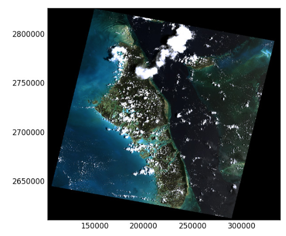
dataset = None结果对比
我们使用一景GF3影像做测试,去噪前:

去噪后:

局部放大对比,去噪前:


哨兵1影像的去噪前后对比
去噪前

去噪后

局部放大对比,去噪前:

局部放大对比,去噪后:

再放大对比,去噪前: